 Introduction
Within the heart of downtown Indianapolis is the
White River State Park. Having a state park in the middle of a major
city is unusual. It is an oasis free of automobile traffic, tight
spaces and din of an urban environment. The only noise is the sound
from the waterfalls and fountains with a feeling of spaciousness from enormous
expanses of lawn and wide pedestrian malls. The sole reminders of
its central urban setting are several spectacular views of the downtown
Indianapolis highrise skyline and is a tribute to the architect(s) that
designed the park.
A major feature and key attraction that ties the park together is the Canal Walk that runs through the park. It follows the general path of a portion of the old Central Canal through downtown Indianapolis. This canal was funded by the state in the 1830's. It was intended to connect the Wabash Canal with the Erie Canal and promote trade and commerce along its length. This was a time prior to rail commerce. Rivers and canals were a major means of long distance transportation. It met financial disaster for reasons I am not yet clear about. It might have eventually succeeded were it not for the development, improvement and speed of rail travel. Rail freed long distance trade and commerce from the banks of major rivers and canals just as the development and growth of passenger air travel after W.W. II was the death knell for passenger trains and ultimately ocean liners.
The first visit to White River State Park and its Canal Walk found an area rich with interesting architecture, landscape and sculpture. On a clear sunny day this is a photographer's dream. Each successive visit finds another perspective to photograph and can be a study in itself to hone one's architectural and landscape photography skills. Since I live in Kokomo, about 55 miles north of downtown Indianapolis, it requires arising early and spending the entire day there to catch the early morning and late afternoon sun angles.
This is a visual essay about the park and its Canal Walk using photographs compiled over several visits. I already have a list of several more aspects to photograph on my next visit. Let your mouse do the walking here and some time when you are in downtown Indianapolis take the walk yourself. The images alone only present a taste of the entire environment found in White River State Park.
Relatively small images of lower resolution are embedded in the text that follows. To see the full-size version with high resolution, simply click on the image with your mouse. To get back to the text and continue the essay, use the "Back" button on your browser menu toolbar. These photographs are best viewed in 32-bit color and the monitor set for 800x600 pixel resolution. They are also in the galleries for the cameras used to take them.All of the photographs are 35mm format. Most of them were taken using an Olympus OM-10 SLR with Manual Adapter. Most of these were with a 50mm f/1.8 OM F.Zuiko standard lens. A few were with a 28mm f/3.5 OM Zuiko or 75~150mm OM Zuiko Zoom. A couple were taken using a Zeiss Ikon Contax IIIa "Color Dial" with its Carl Zeiss 50mm f/1.5 Sonnar. All were taken hand-held (no tripod).
Canal Walk Photographic Essay
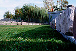
 The
upstream (north) end of the Canal Walk runs north and south along the west
side of downtown Indianapolis and is north of the White River State Park.
Resort hotels and condominiums are found along this stretch of the canal
which is about a story below street level isolating it from the rest of
the city. A broad walkway lines each side. Small foot bridges
periodically connect one side of the canal to the other and steps leading
to ground level are found at major street intersections.
The
upstream (north) end of the Canal Walk runs north and south along the west
side of downtown Indianapolis and is north of the White River State Park.
Resort hotels and condominiums are found along this stretch of the canal
which is about a story below street level isolating it from the rest of
the city. A broad walkway lines each side. Small foot bridges
periodically connect one side of the canal to the other and steps leading
to ground level are found at major street intersections.
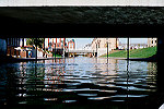
 This
is a peaceful area and some portions get little direct sun except at mid-day.
Since it is below ground level the buildings on each side provide the shade.
Numerous waterfalls and fountains can be found along here and the sound
of water fills the air. This small waterfall with a tinyl pool at the bottom
is embedded in steps leading up to condominiums/apartments. It's
just a small trickle to provide the sound of running water. Other
fountains and waterfalls line the walk, some of which turn themselves on
and off periodically.
This
is a peaceful area and some portions get little direct sun except at mid-day.
Since it is below ground level the buildings on each side provide the shade.
Numerous waterfalls and fountains can be found along here and the sound
of water fills the air. This small waterfall with a tinyl pool at the bottom
is embedded in steps leading up to condominiums/apartments. It's
just a small trickle to provide the sound of running water. Other
fountains and waterfalls line the walk, some of which turn themselves on
and off periodically.
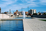
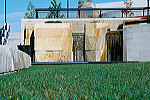
 At
the point the canal turns west to enter White River State Park it runs
right along side the lower level cafeteria of an Indiana State Government
Center. The roaring sound of rushing water increases as one nears
the government building. Then this large columned waterfall comes
into view. A bridge connecting to two sides of the canal has its
platform in the middle directly in front of it. The waterfall is
in the shade most of the day receiving direct sun only late in the afternoon
with a low western sun. Paddle boats can be rented during the day
just behind this view of the waterfall.
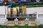
At
the point the canal turns west to enter White River State Park it runs
right along side the lower level cafeteria of an Indiana State Government
Center. The roaring sound of rushing water increases as one nears
the government building. Then this large columned waterfall comes
into view. A bridge connecting to two sides of the canal has its
platform in the middle directly in front of it. The waterfall is
in the shade most of the day receiving direct sun only late in the afternoon
with a low western sun. Paddle boats can be rented during the day
just behind this view of the waterfall.
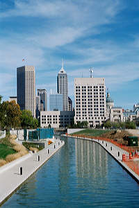
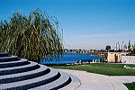
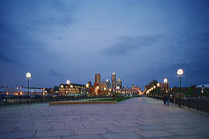
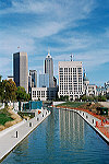 Heading
west from the large waterfall passes a large fountain into White River
State Park on the southern edge of Military Park. The canal opens
up from the buildings that surround its north end transforming the environment
from a feeling of seclusion into one of spaciousness. One of the
best views looking east at the downtown skyline is on a footbridge over
the canal connecting the southwest corner of Military Park to White River
Park. The paddle boats can use this and the northern canal section.
During the afternoon one can see the buildings reflected in the canal water
from here and the view is very good at night. Lights illuminate the
walkway at night giving a superb night view of the canal and skyline also.
Heading
west from the large waterfall passes a large fountain into White River
State Park on the southern edge of Military Park. The canal opens
up from the buildings that surround its north end transforming the environment
from a feeling of seclusion into one of spaciousness. One of the
best views looking east at the downtown skyline is on a footbridge over
the canal connecting the southwest corner of Military Park to White River
Park. The paddle boats can use this and the northern canal section.
During the afternoon one can see the buildings reflected in the canal water
from here and the view is very good at night. Lights illuminate the
walkway at night giving a superb night view of the canal and skyline also.
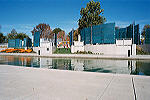 The
Congressional Medal of Honor Memorial is on the south edge of Military
park along the bank bordering the canal. This is well worth visiting.
It is unique in its curved glass panels listing the names and service branch
of all the recipients of the Congressional Medal of Honor. During
the day an audio system periodically tells the story of one of the recipients.
Each of the panels covers a separate time period in U.S. military history,
including times of "peace" inbetween major wars and conflicts. A
little known fact is each of the U.S. Unknown Soldiers is automatically
awarded the Medal of Honor. They are also listed in their own place
on the panels. At night lights at the base of each panel illuminates
them.
The
Congressional Medal of Honor Memorial is on the south edge of Military
park along the bank bordering the canal. This is well worth visiting.
It is unique in its curved glass panels listing the names and service branch
of all the recipients of the Congressional Medal of Honor. During
the day an audio system periodically tells the story of one of the recipients.
Each of the panels covers a separate time period in U.S. military history,
including times of "peace" inbetween major wars and conflicts. A
little known fact is each of the U.S. Unknown Soldiers is automatically
awarded the Medal of Honor. They are also listed in their own place
on the panels. At night lights at the base of each panel illuminates
them.
 After
Military Park and the Medal of Honor Memorial is the large Indiana University/Purdue
University at Indianapolis campus. The canal turns south briefly
here and past the NCAA Hall of Fame, then heads west again towards the
White River. At the turn west it finally emerges at ground level
as the ground gradually slopes downward toward the river.
After
Military Park and the Medal of Honor Memorial is the large Indiana University/Purdue
University at Indianapolis campus. The canal turns south briefly
here and past the NCAA Hall of Fame, then heads west again towards the
White River. At the turn west it finally emerges at ground level
as the ground gradually slopes downward toward the river. 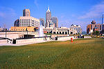 The
broad walkways continue on both sides at canal level, but there are several
ramps, bridges and sets of steps for access from various directions.
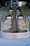
This is a view of the turn west where there are steps, a fountain and a
semi-secluded area to sit between the steps and enjoy the view. Step
out of the seclusion by the fountain to view the Indianapolis skyline in
the background which is continuing to grow to the south.
The
broad walkways continue on both sides at canal level, but there are several
ramps, bridges and sets of steps for access from various directions.
This is a view of the turn west where there are steps, a fountain and a
semi-secluded area to sit between the steps and enjoy the view. Step
out of the seclusion by the fountain to view the Indianapolis skyline in
the background which is continuing to grow to the south.
 Following
the canal further takes you to its end in an ampitheater on the bank of
the White River where there is an upper and lower falls. From the
ampitheater you can sit and veiw the smaller upper falls. It is picturesqe
from several vantage points in the ampitheater and a walkway leads a viewpoint
above the upper falls as to its base between the two looking out over the
river. Occasionally an artist with sketch pad is in the ampitheater
making drawings of the views.
Following
the canal further takes you to its end in an ampitheater on the bank of
the White River where there is an upper and lower falls. From the
ampitheater you can sit and veiw the smaller upper falls. It is picturesqe
from several vantage points in the ampitheater and a walkway leads a viewpoint
above the upper falls as to its base between the two looking out over the
river. Occasionally an artist with sketch pad is in the ampitheater
making drawings of the views.
 Indiana
limestone blocks can be found throughout the canal walk but here in the
ampitheater large blocks of it are used everywhere. It has a unique
yellow cast to it. On many of them the marks from the rock drills
used to cut the stone blocks at the quarries are quite visible. The
limestone blocks are used in the waterfalls, to line the path and to terrace
the ampitheater. A path leads up the side of the ampitheater from
the falls, past the rows of limestone blocks.
Indiana
limestone blocks can be found throughout the canal walk but here in the
ampitheater large blocks of it are used everywhere. It has a unique
yellow cast to it. On many of them the marks from the rock drills
used to cut the stone blocks at the quarries are quite visible. The
limestone blocks are used in the waterfalls, to line the path and to terrace
the ampitheater. A path leads up the side of the ampitheater from
the falls, past the rows of limestone blocks.
 Circular
granite steps end of the path out of the ampitheater. Looking back
into the ampitheater from the steps gives a view of the ampitheater, the
upper falls at the end of the canal, and the White River in the distance.
Circular
granite steps end of the path out of the ampitheater. Looking back
into the ampitheater from the steps gives a view of the ampitheater, the
upper falls at the end of the canal, and the White River in the distance. 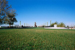 Around
these steps is what used to be the Washington Street bridge. Running
east and west, Washington Street is also U.S. Highway 40 which follows
the general path of the National Road funded by Congress in the early 1800's.
The bridge crosses at a bend in the White River as it continues east.
Washington Street is now diverted around the park and the bridge is now
a pedestrian mall lined with prominent lights down each side. The
first thing noticed though are the large pieces of artwork placed down
the center.
Around
these steps is what used to be the Washington Street bridge. Running
east and west, Washington Street is also U.S. Highway 40 which follows
the general path of the National Road funded by Congress in the early 1800's.
The bridge crosses at a bend in the White River as it continues east.
Washington Street is now diverted around the park and the bridge is now
a pedestrian mall lined with prominent lights down each side. The
first thing noticed though are the large pieces of artwork placed down
the center.
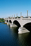 Before
entering the bridge which runs east and west a trip to the White River
Park Visitor Center might be worthwhile as it is one of the few places
along the entire walk with public restrooms! The center resides in
what was the Indianapolis water pumphouse. Built in 1871 it provided
the first public water service for Indianapolis and has portions of the
pumping station restored inside. The canal's water drove its turbines.
Exiting the visitor center, go straight toward the railing along the river's
edge instead of the bridge entrance. There is a good view there of
the bridge's arched architecture and footings along its south side.
Before
entering the bridge which runs east and west a trip to the White River
Park Visitor Center might be worthwhile as it is one of the few places
along the entire walk with public restrooms! The center resides in
what was the Indianapolis water pumphouse. Built in 1871 it provided
the first public water service for Indianapolis and has portions of the
pumping station restored inside. The canal's water drove its turbines.
Exiting the visitor center, go straight toward the railing along the river's
edge instead of the bridge entrance. There is a good view there of
the bridge's arched architecture and footings along its south side. 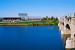 Washington
street used to run directly in front of the old pumphouse. Closer
to the bridge entrance is a good view of the glass conservatory and other
facilities from the back of the White River Gardens. A very new attraction
to the park, it has over three acres of gardens. Also on the other
side of the bridge is the Indianapolis Zoo. Little known is a nearly
hidden path at far end of the bridge that goes between the gardens and
zoo allowing access to the entrances of both the gardens and the zoo.
Also little known is another half-mile path called the River Promenade.
It follows the south bank of the White River along the back of the zoo
and exits at White River Parkway.
Washington
street used to run directly in front of the old pumphouse. Closer
to the bridge entrance is a good view of the glass conservatory and other
facilities from the back of the White River Gardens. A very new attraction
to the park, it has over three acres of gardens. Also on the other
side of the bridge is the Indianapolis Zoo. Little known is a nearly
hidden path at far end of the bridge that goes between the gardens and
zoo allowing access to the entrances of both the gardens and the zoo.
Also little known is another half-mile path called the River Promenade.
It follows the south bank of the White River along the back of the zoo
and exits at White River Parkway.
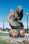 Entering
onto the bridge past the first sculpture is another interesting and colorful
one made of Indiana limestone. It is carved from a stack of limestone
slabs. The colors revealed in the carving are intriguing with hues
of yellow, green red and black.
Entering
onto the bridge past the first sculpture is another interesting and colorful
one made of Indiana limestone. It is carved from a stack of limestone
slabs. The colors revealed in the carving are intriguing with hues
of yellow, green red and black. 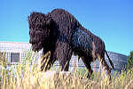 The
last sculpture on the bridge just before the zoo and gardens is a bison
made completely of nearly black wire. The wire bison is mounted on
a pedastal of limestone set in a sea of prairie grass. It is best
viewed on a clear day, either in the early morning from this side, or in
the late afternoon from the other side, so that the direct sunlight brings
out the detail in its surface.
The
last sculpture on the bridge just before the zoo and gardens is a bison
made completely of nearly black wire. The wire bison is mounted on
a pedastal of limestone set in a sea of prairie grass. It is best
viewed on a clear day, either in the early morning from this side, or in
the late afternoon from the other side, so that the direct sunlight brings
out the detail in its surface.
 It
is worth traveling back and forth across the bridge on both sides to look
at the various views offered from the bridge. About halfway across
on the north side a portion of the upper falls and the entirety of the
lower falls at the end of the canal can only be seen completely from the
bridge. The best time is in the late afternoon with the sunlight
highlighting the water in the falls. Visible are more of the Indiana
limestone blocks and the walkways around the falls. The sound of
the falls can be heard even from the bridge. This view can easily
be missed walking down either the middle or south side of the bridge.
It
is worth traveling back and forth across the bridge on both sides to look
at the various views offered from the bridge. About halfway across
on the north side a portion of the upper falls and the entirety of the
lower falls at the end of the canal can only be seen completely from the
bridge. The best time is in the late afternoon with the sunlight
highlighting the water in the falls. Visible are more of the Indiana
limestone blocks and the walkways around the falls. The sound of
the falls can be heard even from the bridge. This view can easily
be missed walking down either the middle or south side of the bridge.
 This
last scene concludes the photographic tour of the Canal Walk. Looking
east about halfway across on the south side of the bridge is perhaps the
second best place to see the Indianapolis skyline with an unobstructed
view straight into the heart of Indianapolis down Washington Street.
Besides being aesthetically beautiful it is one of the locations along
the Canal Walk that serves as a subtle reminder of White River State Park's
venue in the center of Indianapolis.
This
last scene concludes the photographic tour of the Canal Walk. Looking
east about halfway across on the south side of the bridge is perhaps the
second best place to see the Indianapolis skyline with an unobstructed
view straight into the heart of Indianapolis down Washington Street.
Besides being aesthetically beautiful it is one of the locations along
the Canal Walk that serves as a subtle reminder of White River State Park's
venue in the center of Indianapolis.
Thanks for visiting this site and hoping this page has been enjoyable. If you are interested in and enjoy photography, visit the home page and go from there to the Olympus, Rollei or Contax pages (the Mamiya section is still under construction). There are links to galleries of photographs taken using these various camera systems, plus some descriptions of the camera systems and the history behind them.Take a Virtual Reality Tour of the Indianapolis Canal Walk!